Sold as a year round destination South Africa has two distinct weather patterns. Cape Town, Garden Route and winelands enjoy a dry summer between October and March making it the ideal time of the year to travel to the Cape. Conversely, the rest of the country has a wet summer, making the winter months between June and October the ideal, and drier, time to travel for wildlife.
Overview
Climatically, South Africa is influenced by its latitudinal range, its altitude and its proximity to two ocean fronts.
Geography
South Africa is Africa’s southern most country. It is bordered in the north by Namibia, Botswana, Zimbabwe and Mozambique, in the east and southeast by the Indian Ocean, and in the west and southwest by the Atlantic. It is situated on a latitudinal range of 25° – 33°, which means it comes under the stabilising influence of largely tropical air masses, producing a climate characterised by a wet season and a dry season.
Topographically, South Africa divides into 3 geological zones: its coastal margins, a vast interior plateau and the Kalahari basin. The margins in the east are reasonably wide (80 – 240km), while those in the west are less broad (60 – 80km). The central plateau rises gradually from west to east, with altitudes averaging at about 1,200 – though clearly the east and north east is much higher.
South Africa’s marginal zones are influenced by the effects of the respective oceans’ currents. The Indian Ocean is warmed by the south flowing Agulhas, its moist air mass providing the coastline of Kwazulu-Natal and much of that of the Eastern Cape with their high levels of humidity, their tropical feel. The Atlantic, on the other hand, is cooled by the north flowing Benguala current, and its dry air mass produces arid conditions along much of South Africa’s western coasts. The influence of these currents wanes the further one travels inland.
Seasons
South Africa’s latitudinal stretch, its range of altitudes and the contrasting influences of its oceans means that the country has no less than 5 climatic zones: the Kalahari basin (semi-desert, desert), the fynbos (Mediterranean), the Highveld (semi-arid to savannah), the Karoo (elevated arid to semi-desert) and the Drakensberg (mountain).
Generally speaking, therefore, the wet season, the southern hemisphere’s summer, occurs between October and March, the dry season, its winter, June through to August, while spring is September and Autumn April and May. Depending on where you are in the country, daytime temperatures for the wet season can push up into the early thirties, making travelling a somewhat hot and humid affair. The quality of the rain at this time is equally dependent on position – latitude, altitude and oceanic influence – with the north-east and eastern coastline receiving roughly twice as much rain as the interior, which, in its turn, receives twice as much as much of the western half of the country – the Cape Province and Garden Route excepted. The winter months are cooler, with a daytime temperature range of about 25°C – 30°C.
In certain areas – the Northern Cape, for example – this temperate cycle is either diluted by the combination of the Atlantic air currents’ relatively low moisture content and an average temperature of 18°C having the effect of producing long dry seasons and relatively dry wet seasons; or it is, as in the Cape Province, turned entirely on its head, where, due to its high level of latitude and to the influence of the Atlantic front, the wet season occurs in the winter, the dry in summer.
Influence
Given the above, it is possible to travel to South Africa at any time of the year, with Cape Town, the fynbos and the winelands offering an ‘out of season’ experience. However, the majority of wildlife areas are not situated in the Western Cape. What is true of, say, Botswana or Mozambique is also true of South Africa: the best game viewing takes place during the dry season, when the animals are forced to exploit fewer sources of water, and when the cover is greatly reduced.
During the wet season, the animals are afforded greater cover, are more widely dispersed and therefore are much more difficult to spot. This said, it is also true to say that some experienced travellers and specialists prefer the wet season: the game is in better shape; it is when many species calve; behaviour changes; and it is the time for watching birds. Nonetheless, unless a specialist, very experienced, a bird watcher or visiting Cape Town and its surrounding environs, May through to the end of Septemberare the best times to travel in South Africa, with the peak season being June, July and August.
Areas
Journeys by Design designs itineraries for the following South African destinations: Kruger National Park and surrounding areas, Kwazulu-Natal, the Waterberg Savannah biosphere, Cape Town, the winelands, the Garden Route and Eastern Cape, the Kalahari and Johannesburg and Pretoria.
Western Cape
In contrast to the rest of the South Africa, most of the Western Cape experiences a maritime Mediterranean climate*, with the winter months wet and cool, the summer hot and dry. In general, levels of precipitation range between 300mm along the coastal bands to 1,500mm plus in inland high altitude areas, most of which falls between June and August, when rain carrying north-westerly winds prevail. The temperature at this time ranges between 7 °C and 17°C. Things warm up between November and March, with temperatures averaging in the mid-twenties.
However, the combined effect of the Benguala and Agulhas currents and an extremely varied topography means that microclimates abound, temperatures vary and levels of precipitation across a few kilometres depend on local altitudes. What follows, therefore, is a brief look at the climate and how it influences travel in just those destinations currently used by Journeys by Design. They are: Cape Town, Table Mountain, the Winelands, the stretch of coast between Cape Town and Walker Bay, Cedarberg Mountains and the beginnings of the Garden route, from Heidleberg to Plattenberg Bay**.
The Cape Town bowl receives an average of 515mm rain per year. Temperatures range between an average of 11.4°C and 22°C, the months between May and October cooler, those between November and May exacerbated by the Berg Winds, which bring added heat (from the Western Cape Karoo) in January and February, and by the dry south-easterly winds, known locally as the Cape Doctor – it helps reduce the city’s levels of dry season pollution. As a result of the above mentioned oceanic currents, water temperatures depend on location, with the western Atlantic seafront experiencing an average 10°C, the south-easterly Atlantic 22°C.
While still a maritime Mediterranean climate, the levels of rainfall in areas around Cape Town depend very much on position and /or altitude.
Climatically, the coastal strip between Cape Town and Walker Bay is similarly temperate. Grootbos Private Nature Reserve, sitting – at its highest point –at 520m, experiences 680mm of rain per annum, is coolest in July, hottest in February, with temperatures ranging between 14°C and 25°C.
The Cape Fold Belt, a mountainous range running from the Cedarberg Mountains in the northwest through to Port Elizabeth in the Eastern Cape, is as a rule wetter than Cape Town, with Table Mountain averaging 1400mm per annum, but again relatively dry wind currents flowing in off the western Atlantic mean that the Cedarberg Mountains are a lot drier than altitude would suggest, with average rainfalls of between 400mm and 700mm. Here temperatures in the summer can reach 40°C, while winter sees snow on some of the highest peaks. Spring and autumn (September and May) are the easiest seasons, with temperatures averaging out at around 25°C.
Located at latitude 27° – 34°, occupying an altitudinal range of between 300m*** to 1,300m, cooled by the south-easterly winds, and grown in well-drained soils, the Western Cape’s vineyards are – climatically speaking – perfectly positioned. Benefiting first from a generally temperate Mediterranean climate, the farming potential of the area is further bolstered by numerous mecroclimates, all of which provide Winelands localities with varying temperatures and levels of rainfall, which – when combined with the many soil types – makes for great variation of varietals.
All of which means that, in general, the Western Cape is best visited between September and May. September is when the fynbos (see accommodation Grootbos Private Nature Reserve) is at its most vibrant, while the dry summer makes for excellent hiking, site seeing and sampling wines on hotel and lodge terraces. September through to December is good for whale watching.
*A section of the Western Cape interior is semi-arid, experiencing along with the north-west and parts of the central plateau, a dry tropical climate.
**For logistic purposes the western Garden Route is included in The Eastern Cape and Garden Route
** *Some vineyards thrive at as low as 150m.
Kruger NP and concessions
The Kruger National Park and neighbouring concessions is located in the north-east of South Africa. It is a part of the Great Limpopo Transfrontier Park and includes a number of neighbouring concessions, chief of which are the game reserves Sabi Sand, Manyaleti, Timbavati, Thornybush, Kingstown and Makalali.
The greater Kruger experiences a semi-arid to humid climate. Located at latitude 25°, in a climatic zone known in South Africa as the Lowveld, it is a part of a savannah biome that extends down much of eastern Africa. Watered by a number of rivers, including the Sabie, Sand, N’wantetsi, Sweni, Olifants, Limpopo, Letaba, Crocodile and Luvuvhu rivers, the area is characterised by 6 ecosystems: baobab sandveld, knobthorn-marula bushveld, mixed acacia thicket, leadwood and silver clusterleaf, woodland on granite, and riverine forest.
Overwhelmingly influenced by subtropical air masses, the region experiences two distinct seasons: dry and wet. The dry season occurs between June and August, the wet season between October and April. September and May are the transition months, the former the region’s spring, the latter autumn. The area as a whole receives an average of 800mm of rain per annum and temperatures range from an average daily maximum of 26.1°C in the winter months to a fairly uncomfortable daily maximum of 32.4°C during the summer. However, given that the size of the area and the fact that it falls away from west to east, with the south-west reaching 864m at its highest, the borderlands 200m, rainfall levels vary slightly across the region.
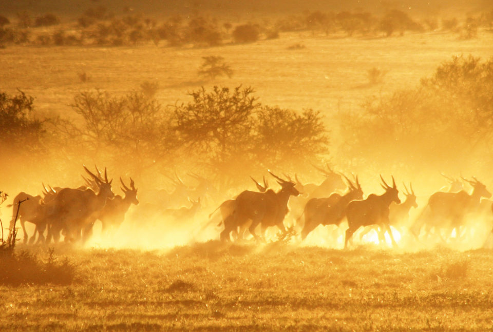
The greater Kruger’s fauna is driven by the seasons. The dry season is best for game viewing, when animals are forced to utilise permanent water sources; the wet season sees the park at its prettiest, and is excellent for birds.
June through to August is peak season. At this time, the grasses are in recession, the trees largely bare, and the prevalent colours are yellow and brown. With the cover all but decimated, and seasonal water holes dry, the game masses along the river fronts.
September – mid October is still reasonably dry, but the park is beginning to green and temperatures are rising in anticipation of the main rains. Depending on the strength of early rains, the game remains concentrated around the rivers. Migrant birds begin to arrive and courtship rituals abound. With the cover still relatively thin, game viewing at this time remains good to excellent.
While November is fair to good for game, December through to March is the height of summer. Thunderstorms are frequent, the area is super green, rain dependent plants are in flower and the animals are well and truly dispersed. For specialists and very experienced travellers, this is the season, as various species – impala, buffalo, waterbuck and kudu – enter their breeding seasons and behaviour is markedly different. Prey animals are notably fresher, stronger, and carnivores are forced to work a lot harder.
April sees an end to the main rains, temperatures drop, the cover is excellent and trees are beginning to seed. This is the rutting month and prey species such as impala and wildebeest are in fine fettle.
By May the greater Kruger is changing colour. Late flowerers and receding grass makes for paler habitats, and as the temperature drops, animals tend to move to warmer areas. At this time, the northern end of the park’s elephant population is boosted by an influx from Zimbabwe and Mozambique. Resident wild dog packs begin to breed and game viewing improves dramatically towards the end of the month.
Kalahari and the Tswalu Kalahari Reserve
The Kalahari occupies much more than South Africa. Its northern most borders are to be found in Angola. It stretches west into Namibia, and constitutes a large proportion of Botswana. At the moment, Journeys by Design designs itineraries that include the Tswalu Kalahari Reserve, in Kuruman, in the Northern Cape.
The Northern Cape is South Africa’s most arid climatic zone, ranging from semi-arid to semi-desert. While it is does receive the rain, and experiences – along with nearly all of southern Africa – two distinct seasons, the year is much drier than it is wet, with the dry season occurring May – to November, the wet season December through April.
With annual rainfall levels averaging out at around 240mm, the Kalahari itself is not desert in the truest sense of the word. Indeed, there are areas outside of the Kalahari – to the west, along the coast – that receive 100mm or less per annum, and lay greater claim to desert status. Nevertheless, it is very much on the edge of being one. The days are hot, the nights cold, the summer months genuinely uncomfortable, the winter much more manageable. The extremely dry conditions are the result of the effects the Benguala, the predominant and north flowing Atlantic current, whose cool and dry air mass provides little rain, the majority of its water vapour being evaporated by the Kalahari’s surface temperature.
In general, three types of bushveld dominate – dune, mountain and thorn – and their location depends on altitude and position. The north-western tip of South Africa’s Kalahari (approximately 1000m) receives 200mm of rain per year, has a temperature range of -10°C to 45°C and as such manages to support just a dune bushveld, while the west, which includes the Rogela Pan, is slightly less hostile, stands at 1050m, receives 300mm per year, ranges from -9°C to 42°C and is able to provide for both dune and thorn bushvelds. All three bushvelds are found in the south-east, in the Tswalu Kalahari Reserve, which in places reaches 1586m, receives up to 350mm a year and is, at -9°C to 40°C, slightly cooler. All three bushvelds are composed largely of shrubs, different types of grasses and very few trees.
With little rain, low cover and a short rainy season, the rule vis-a-vis the dry season being the best time to view animals is not so true of the Kalahari. The rains, when they come, are sudden and heavy, and the desert turns green overnight. At this time, gemsbok, blue wildebeest, eland and red hartebeest, drawn to fresh pastures, will begin to mass in herds, their presence attracting lion, cheetah and leopard. During the dry season, migratory animals travel north into Botswana, while residential specialists tend to disband, and forage or hunt in pairs or solo.
Johannesburg, Pretoria and the Waterberg Savannah Biosphere
South Africa’s Highveld is an enormous central plateau consisting of Free State and great tracts of the Northern Cape and Mpumalanga. Strictly speaking, the Waterberg Savannah Biosphere lies north of the main plateau, and is in parts higher or lower, but it shares many of the northern Highveld’s climatic characteristics, which is why we have included it in this section. Other destinations on the Highveld include Johannesburg and Pretoria.
Part of the reason why Johannesburg has survived its now dormant mining legacy is its climate. Generally fine the year round, Johannesburg is located at 1753m and experiences a subtropical highland climate, with an average of 713mm of rain a year and an average high temperature of 21°C. October through to April is when it rains, and these are the hotter months, but the rain generally comes in the afternoon, as thunderstorms, leaving the rest of the day bright and relatively rain free. The dry season runs from May to September, is much cooler (temperatures in June drop to around 16°C) and the nights can be possibly frosty. Note: August is when the winds come, and the air is intermittently filled with a fine dust, picked up from residual mining slag heaps.
Nearby Pretoria experiences an almost identical climate, only it is lower (1,350m) and – owing to being located in a valley that acts as a suntrap – warmer (average high temperature 25°C) and receives 674mm of rain per year. Thus, all that is true of Johannesburg is true of Pretoria – except the August dust, of course.
The Waterberg Savannah Biosphere has an altitudinal range of 830m and 2,085m, a mean annual precipitation level of 600mm and a daytime temperature range of between 14°C and 25°C. The dry season runs from May to September, with June and July relatively cool and August and September hot and humid. The wet season begins in November and finishes in March. April is autumn and a transition month while late September to early November is spring.
A tropical savannah and grasslands biosphere containing bushveld, wetlands, riverine forest and rocky cliff and outcrops, the Waterberg experiences dry and wet cycles spanning approximately an average of 8 years, and is currently (2011) 4 years into a wet cycle. While its levels of annual rainfall – which range between 485mm and 719mm – are not exceptional, there are plenty of permanent sources of water, and the water is of exceptional quality, all of which means that the Waterberg supports a largely residential game population, with internal migrations accounting for much of the movement. As with the Kruger, the dry season is excellent for game viewing, the wet season for birds and specialist game interest.
Kwazulu-Natal
Kwazulu-Natal is located on the east coast of South Africa. It is the country’s wettest, most typically tropical province, and experiences a standard southern Africa bimodal climate, with the wet season being October – April, the dry season June – August, the transition months late April-May (autumn) and September (spring). At the moment, Journeys by Design designs itineraries that include Durban and the coast, Thanda and Phinda game reserves and Fugitives Drift.
Uncomfortable during the summer, when temperatures reach into the early thirties and the afternoons are blasted by thunderstorms, Durban and the coastline are extremely hot and humid between October and April. Things cool down in the winter. Temperatures fall to an average of 20°C and the water clears, making May – September the best time to swim, snorkel, dive and surf. The fishing season begins in Easter and peaks June-July time with the annual sardine run. The Durban area receives an average of 1054mm per year.
Inland, Phinda Private Game Reserve is situated on a largely flat coastal plain, with an elevation of 4m to 350m, and home to 7 microhabitats and to a range of introduced carnivores and herbivores. Here, the level of rainfall falls off markedly, averaging out at 500mm (though ranging from 405mm to 865mm, depending on the year), and the two main rivers, the Mzinene and the Munyawana, are seasonal. It rains all year round, though only nominally during the main winter months. Maximum temperatures during the summer are 33°C and 25°C in the winter.
Given Phinda’s mixed habitat, game viewing depends a great deal on where one is, and on the type of animal likely to habituate a given ecological zone; however, it is true to say that, as with the Kruger and the Waterberg, the dry season is much the better part of the year, when the cover is greatly reduced, and the animals are forced to utilise fewer water sources.
Slightly further north, but on the same line of longitude, Thanda Private Game Reserve has a similar climatic profile to that of Phinda, and is best visited during the dry season, when the rains are minimal, when it is cooler and when the game is similarly massed about permanent water sources.
Finally, Fugitives Drift, which is further inland and much cooler, is best visited between April and September, when it is relatively dry and warm.
The Eastern Cape and the Garden Route
The Eastern Cape lies between the typically tropical climate experienced by that of Kwazulu-Natal and that of Cape Town and its surrounds, which are Mediterranean. Generally speaking, the province is tropical, with the coast experiencing wet, humid summers and dry winters, and the inland plateau and Greater Karoo the same rainfall patterns, but much drier. Journeys by Design currently designs itineraries that include Plattenberg Bay, Phantom Forest and Samara Private Game Reserve.
The Samara Private Game Reserve is located in the Greater Karoo, near Graaff-Reinet. A semi-desert region, it is located on the southern flank of the Sneuberg Mountain range and receives an average of 236mm (Graaff-Reinet) of rain per year. The rainy season begins in October and lasts through to April, the dry season from May to September. The summer can be hot, with temperatures reaching the early thirties, but the days are tempered by Samara’s high altitude – over 2000m – and the nights rarely exceed 15°C. The winter months are much cooler, with daytime temperatures ranging from 16°C to 22°C. Nights can be very cold at this time – between 0°C and 3°C June-July – so pack accordingly.
Despite its semi-desert status, the reserve covers 4 different habitats – grassland, Nama Karoo, valley thicket and savannah – and supports a range of animals, cheetah, Cape mountain zebra, black wildebeest, eland, kudu, gemsbok, red hartebeest, vervet monkey and meerkat. As is common with all game areas located within a tropical climatic zone, the dry season presents the best prospects vis-a-vis game viewing – when the cover is greatly reduced, and the animals are forced to utilise fewer water sources.
The Western Cape’s Garden route is a perennially green band running between Plattenberg Bay and Heidleberg. Climatically, things here are on the turn, the Eastern Cape’s dry winters and wet summers gradually replaced by the Western Cape’s maritime Mediterranean climate. This is the country’s climatic buffer zone, and theoretically it rains all year round – though somewhat unevenly, with specific months much wetter than others, depending where you might be en-route.
Phantom Forest Eco Reserve is located just inside the Western Cape and experiences a climate typical of the transition from tropical to Mediterranean, with rain guaranteed all year round. A forest habitat, Phantom Forest receives approximately 800mm of rain per annum and temperatures are constant, ranging from 18°C in July to a January high of just 24°C. Known for its mixed habitats of fynbos, montane forest and wetlands, it is good for visiting all year round.
At Plattenberg Bay, which marks the eastern most point of the Western Cape, rainfall levels average out 700mm, and while there is rain all year round, it falls mainly in March and August through to November. Mossel Bay, on the other hand, receives an average of 300mm per year, much of it between March and May and in August and November, with June and July very dry. By the time you reach Heidleberg, the climate is well and truly Mediterranean, with much of its annual 588mm of rain falling between March and September.